Catchment Area Boundaries
Catchment Area Boundaries:
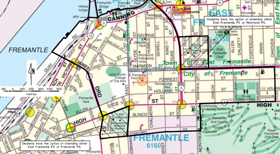
From the intersection of Stirling Highway and Marmion Street, east along Marmion Street to
Coode Street, south along Coode Street to High Street, west along High Street to Montreal Street,
south along Montreal Street to Knutsford Street, west along Knutsford Street to Swanbourne
Street, north along Swanbourne Street to High Street, west along High Street to Ord Street,
north along Ord Street to James Street, north west along James Street to the Fremantle
Harbour, north east along Victoria Quay to the southern bank of the Swan River foreshore, north
east along the Swan River foreshore to Stirling Bridge and Stirling Highway, south east and
south along Stirling Highway to Marmion Street. The boundary parts of Marmion Street (south
side), Coode Street (west side), High Street (eastern section, north side), Montreal Street (both
sides), Knutsford Street (both sides), Swanborne Street (east side), High Street (western section,
north side), Ord Street (east side), James Street (east side) and Stirling Highway (south west
side) are included within this local intake area.
The lined section on the top right is an optional area between East Fremantle Primary School
and Richmond Primary School:
From the junction of Marmion Street and Moss Street, north along Moss Street to George Street,
west along George Street and its extension to Stirling Highway, south along Stirling Highway to
Marmion Street, and east along Marmion Street to Moss Street. The boundary parts of Moss
Street (west side), George Street (south side), Stirling Highway (east side) and Marmion Street
(north side) are included within this optional area.
The lined section on the bottom left is an optional area between East Fremantle Primary
School and Fremantle Primary School:
From the intersection of High Street and Ord Street, east along High Street to Swanbourne
Street, south along Swanbourne Street to Knutsford Street, west along Knutsford Street to Ord
Street and north along Ord Street to High Street. The boundary parts of High Street (south side),
Swanbourne Street (west side), Knutsford Street (both sides) and Ord Street (east side) are
included within this optional area.
